Yosemite Valley
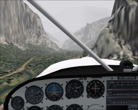
Yosemite Valley  is a famous valley in the Sierra Nevada mountain range of California, United States. The 11 km long and ~1.5 km wide valley is located at 4000' ASL surrounded by 3000'-4000' high cliffs.
Takeoff from Mariposa-Yosemite Airport (O68) in a light aircraft. Maybe you need to gain some altitude to the west before you turn northeast and head for the valley which starts at N37* 43.40' W119* 38.80' (map). At the end of the valley you'll see the Half Dome at N37* 44.76' W119* 31.99'. If you follow the valley at low altitude in a light aircraft you'll need to do a 180° turn at the end of the vally because of terrain.
Scenery add-on
It is highly recommended to install this freeware 9.6m terrain mesh from FSGenesis.