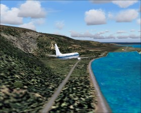
Madeira

Madeira  is an Portugese island west of Africa. Madeira Airport (LPMA) (also known as Funchal Airport) has a single 9100 ft long runway that runs parallel to the sea at one side and hillsides on the other side. Due to the terrain the runway is placed somewhat akward and part of the runway is build on a bridge
 . The airport often suffers from turbulence and crosswind.
The airport has the following remarks:
"Severe turb when wind is 15 Kt (or possibly less) btn 300 and 020 . Downdrafts or updrafts are to be expected near thld of Rwys 05 and 23. When landing on Rwy 23 fr S and W sctrs, exp severe turb at lo alt over rwy thld. With westerly winds, tall windshears may be expected. Due to hi terrain no deviation to lt of apch path in ldg Rwy 05, immed lt turn aft tkof fr Rwy 23. Str-in apch not auth fr Funchal VOR to Rwy 23. Bird haz."
Runway 5 approach
Due to obstacles in front of runway 5 a straight-in landing is not possible. Therefore a special visually right turn of more than 180° is required before lined up with the runway about 1 nm from the threshold. There is two approaches: VOR/DME followed by VOR Visual, and NDB followed by NDB Visual. Download the instrument charts here or here. Remember to apply real-world weather.
A night approach is difficult because of the final visual turn. If the curve is too small you'll not have time to line up with the runway. If the curve is too big you'll hit the hillsides. In real-world approach lights run along the coastline. However, there is a road near the coast which is lighted at dark and which provides excellent visual guidance. Try the night approach without using GPS. In the Boeing 737 with an approach speed of 145 KIAS I use a bank angle of about 20°-25°.
Add-ons
I have only found payware add-ons for Madeira Island and Airport:- Wonderful Madeira by aerosoft
- Madeira Islands by PTSIM
Flights
Make an approx. 1 hour IFR flight from Lisbon, Portugal to Madeira (LPPT-LPMA).