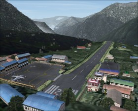
Mount Everest

Mount Everest in Nepal is part of the Himalayas and the highest mountain in the world. The tour is separated into three flights which you need to follow in sequence.
1. Kathmandu - Lukla
You have just arrived at Tribhuvan (VNKT) in Kathmandu, the capital of Nepal. On the first flight you will carry some mountaineers and tourists to Lukla (VNLK) 
 which is close to the mountain. A good choice of an aircraft is the Beechcraft King Air 350 because it is suitable for making short takeoffs and landings at Lukla and flying at high altitudes. Don't file an IFR flight plan because ATC will give you a vector to final where you can't land. Before arriving at Lukla consider to install the add-on described at the bottom of this page.
From VNKT climb to at least 13000 ft while following VOR 112.30 outbound on track 096° for about 70 nm. Now turn on terrain mode (TERR) on your GPS navigator and carefully locate the low elevation valley running north and south with VNLK on its path. Follow the valley to the north while descending to just above the airport elevation at 9100 ft. When you have the airport in sight on your right side line up with the 2500 ft asphalt runway at 60° and land (you need the scenery add-on to get the correct runway).
And a couple of tips: Turn into the valley with low speed and low altitude or you will have problems descending to airport elevation in time. The same is true before you make the final right turn to the runway because there is only little distance to the runway threshold.
2. Lukla - Mount Everest - Lukla
Assuming you are too lazy for climbing the Mount Everst on foot you take a flight from Lukla to the mountain and return to Lukla. The King Air may still be a good choice, simply because you will have to make a very steep climb in a short distance.
Takeoff from Lukla, turn right, and follow the low elevation valley to the north and later north east. Climb to at least FL 290 if you want to cross the mountain. The highest point is at N27* 59.20' E86* 55.52'. Locate the point visually or press Shift+Z to see the current coordinates. Back to Lukla you may follow the same route that lead you to the mountain.
3. Lukla - Kathmandu
Back to Kathmandu you may fly a less direct route at low altitude that gives you time for enjoying the landscape and visiting some local airstrips. Because of the low altitude you may choose a smaller single engine airplane. Use the GPS navigator and follow the valley that goes south from Lukla to NDB LDA and then west to Kathmandu. Pass by the following airports on the route: VNLD, VNRT and VNRC.
Scenery add-ons
These freeware add-ons cover the area of Kathmandu, Lukla, and the Mount Everest top.
- Himalayan Peaks LOD10 Mesh, Volume 1 - Mt. Everest and Kula Kangri by Holger Sandmann and Jonathan de Ferranti
- Himalayan Peaks Volume 2 - Mt. Everest photoreal textures by Holger Sandmann
- Airports of Nepal, version 2.0 by Einar Aarvik
- Airports of Nepal 2.1 (requires v. 2.0) by Einar Aarvik and Halfdan Abrahamsen