Strange airports and places
Remark: This page will not be updated anymore. Please refer to Spectacular places for the lastest FSX places.
This site contains a list of strange places and airports in Flight Simulator. In some cases they are incorrectly represented due to errors in the software, scenery, or mesh etc. Please share your own airports/places in the comment box below.
Icons:
 Valid for Flight Simulator 2004
 Valid for Flight Simulator X
(none): Valid for Flight Simulator 2004, but not checked yet in Flight Simulator X
ENDI: Major terrain mesh bug
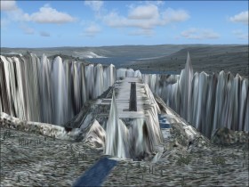
From SYKM fly south and see a very tall spear and very deep hole.
Deep holes: From 2AR6 rwy 19 fly rwy heading. From MO3 fly heading 120.
9AK8: This airstrip is located near several other airstrips. The problem is, that the airstrip elevation is 200-300 ft below the other airstrips.
VNLK and VQPR: Two Himalayan airports with difficult approaches.
KMKO: Runway placed on top of a hole
Airports located in a hole: SESM, SPVL, FZNI, LAKO, MXA9, MDCZ, VI1Y, 44AK, SVAS, 4Z5, 80WA
Airports located on a platform: MT84, BGUK, SPPY, SPIN, VE1N, SBCJ, 15NK
Southeast of MS65: Platform with fueling station, light mast and terminal building, but no registered airport.
Southeast of SESM: While SESM is probably located too low (only in FS2004), this river is located too high
7SP:
The airport/terrain are only partly matching each other.
The terrain is now corrected but the waterholes are still unusual close to the airport
LB1B: Runway located on a platform and part of a highway. Light and power masts very close to the runway.
Antartica airports: Snow and ice runways. Furthermore the runways are moving because of a bug when you get close to the poles.
AQY: Terrain in front of runway thresholds
EGDP: Even though equipped with tower, runway lighting, jet fueling station and asphalt surface this airport in the southern England has a only 750 feet short runway.
VILH: At 10700' elevation this airport has a 535' short runway (6/24). This is the place for testing your STOL aircraft.
KNXP: Runway of steel (there's several of them) VVDB: Runway of planks (there's several of them)
KSZP: Terminal buildings very close to runway. Dangerous for crosswind landings.
EKVG: Special (but true) exit ramps at both runway thresholds if you run out of runway
LXGB: Runway that cutts off the Gibraltar peninsula
WAJJ: If you follow the glideslope for ILS/DME 30 you'll eventually hit the water. Decision height here should be taken seriously!
YPID: Invisible runway but visible taxiways
S93 and 2W1: Two runways with same latitude and heading and 0.3 nm from each other. Even same frequencies.
North and South Poles: If you try to reach the Poles in FS2004 it's like hitting a wall.
Obstacles on or close to the runways/taxiways:EGUW, 4FL3, CJU4, 4A8, LFLJ, SBPN, VOTV, WPEC,KRED, KLWB, LATI, CYGP, CBZ3
31D: Two of the (very small) runways are placed in extension of the main runway.
WN23: A tree and a power mast on the approach for runway 25, and a lighthouse on the runway. Furthermore this airport has only a small (lighted!) grass strip but ironically it has the title of an international airport.
Between SPJN and SPYU: A bridge that connects South America with the Pacific Ocean...
East of SBMN: Bridge connecting land to water.
EDDI and SBRJ: Spectacular (but true) arrangement of taxiways/aprons/buildings.
PAGY: Spectacular road net besides the runway.
RJTE: Very short runway. Fortunately the taxiway extends the runway to twice the length.
CYRV: One of the weirdest airport surroundings in my opinion
YSNF: Runways build on water
FNBG: Runway becomes invisible if you slew the aircraft.
"Water mountains" at S73* 25 W127* 5.
ESSA: The runway 19L/1R is only partly completed and thus represented as a kind of taxiway. A road from outside the airport crosses the runway.
N35* 7.75' W8* 45.13': A small square of land in the Atlantic Ocean.
RJTX: Just a single helipad. Not that this is uncommon, but in FS it is.
EDDF: If you check the facility information you'll see a runway 25L and 26L. Physically it is the same runway, but because the runway has two ILS approaches, the runway has two names.
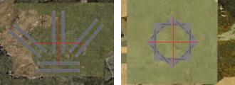
NRQ: Beyond having 8 small runways that together forms a star (in FSX), this US Naval Outlying Field has undergone a very spectacular transformation between FS2004 (left) and FSX (right):
YXFV: In FS2004 this is just a helipad, however, in FSX it is the shortest runway (100 ft) with a light mast and a couple of buildings on the runway. The two visual runway threshold numbers are placed on top of each other.
FBKE